In trying to figure out exactly where Joseph Patterson purchased land in Hall county, Georgia, in 1823, I suspected the district noted in the deed as “tenth” might be incorrect. Instead I thought it should have said “twelfth” as that is where he later sold land, and it was where his mother and brothers owned land. But to know for sure, I needed to find Wahoo Creek which is the body of water mentioned in the deed.
So for a moment I considered what resource could help me find the location of Wahoo Creek in Hall county, Georgia. Initially I checked out both Google and Bing maps and ended up panning around hoping to find it. This was not helpful, particularly because not all stream names are shown. Then I realized I could just use the online map I use all the time at work – the Coordinated Needs Management Strategy or CNMS Viewer!
The CNMS map shows all the bodies of water in the United States, and if it has been studied, you can click on the line for a stream to get its name and all the other data associated with it. The other reason this map is so useful for finding streams is it is GIS-based so I can find a stream by searching the data for its name. So I zoomed into Hall county, searched for Wahoo, and was able to confirm it is in the twelfth district rather than the tenth. And I could verify there is no Wahoo Creek in the tenth district – mystery solved; clerical error in the deed!
Then I started wondering how other genealogists are finding water bodies noted in old deeds. I don’t think many people know about the CNMS viewer unless they use it for work. So I figured since CNMS could be such a great resource for genealogists, I would lay out the whole process of how to use it to find a river, stream, or creek someone may need to find. Below is a step-by-step process:
Step 1
For my first step, I transcribed the deed. This was not only to have a clean, easy-to-read copy, but also to make sure I didn’t miss anything in my analysis. Here is how it came out:
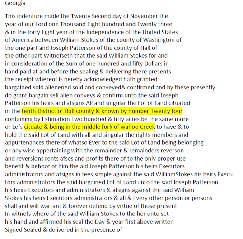
In completing this transcription and highlighting the areas involving location of the land, I realized it is actually on the “middle fork of wahoo Creek.”
Step 2
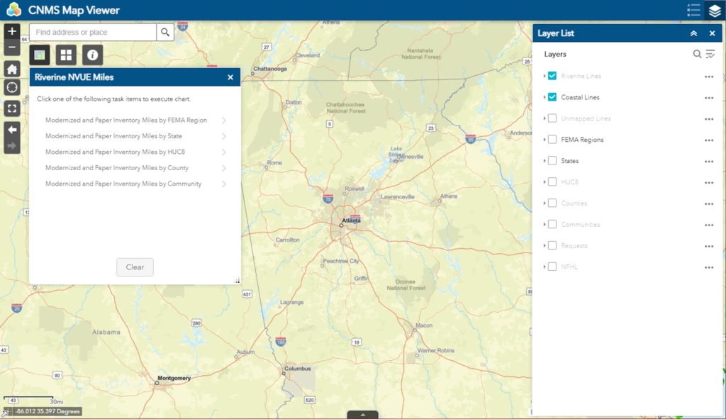
The next step was to go to the CNMS Viewer.. Here is what the viewer looks like when you open it. In this image, I’ve already moved my map over to Georgia by dragging it. I could have closed out of the “Riverine NVUE Miles” window as that is not used for finding a stream. So feel free to close it if it is in the way.
Step 3
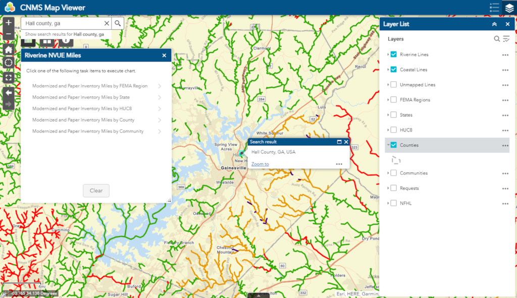
Next, I typed in the location where I wanted to focus my search. This makes it easier to find the stream as it will only need to search a specific area. Because deeds are recorded at the county level, it makes sense to search for a county. In my example, I put “Hall county, ga” in the search bar in the upper left and hit enter. The image below shows the map now centered on Hall county. I have also in the “Layer List” clicked on the “Counties” layer so I can see the county boundaries on the map. These are shown by a gray line. At this zoom level all the streams start showing up as colored lines. The different colors have meanings that are not relevant to our search.
Step 4
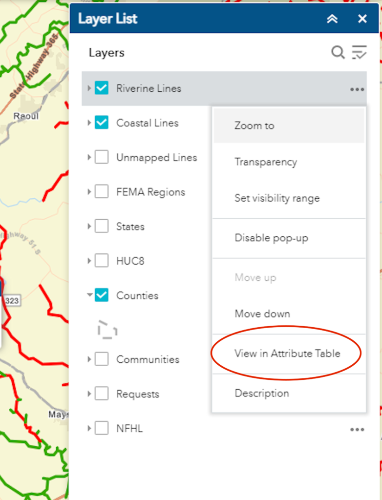
To search the data, we need to have it displayed on the viewer. This is done by clicking the three little dots to the right of “Riverine Lines” in the “Layer List” window. When you click these, a drop down will display as shown in the image below. Click “View in Attribute Table” which is circled in the image to highlight its location in the drop down.
Step 5
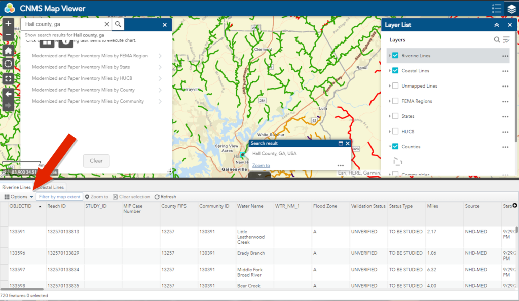
After you click “View in Attribute Table,” the viewer will open a window at the bottom of the screen and take a moment to build the table. Below is how this will look when it is done. Note, in the top bar of the table, the “Filter by map extents” is highlighted. This means the data in the table is limited to only the streams shown in the area currently displayed on the map which is what we want.
Next we need to click the “Options” button in the upper left of the table. A red arrow in the image below shows where this button is located.
Step 6
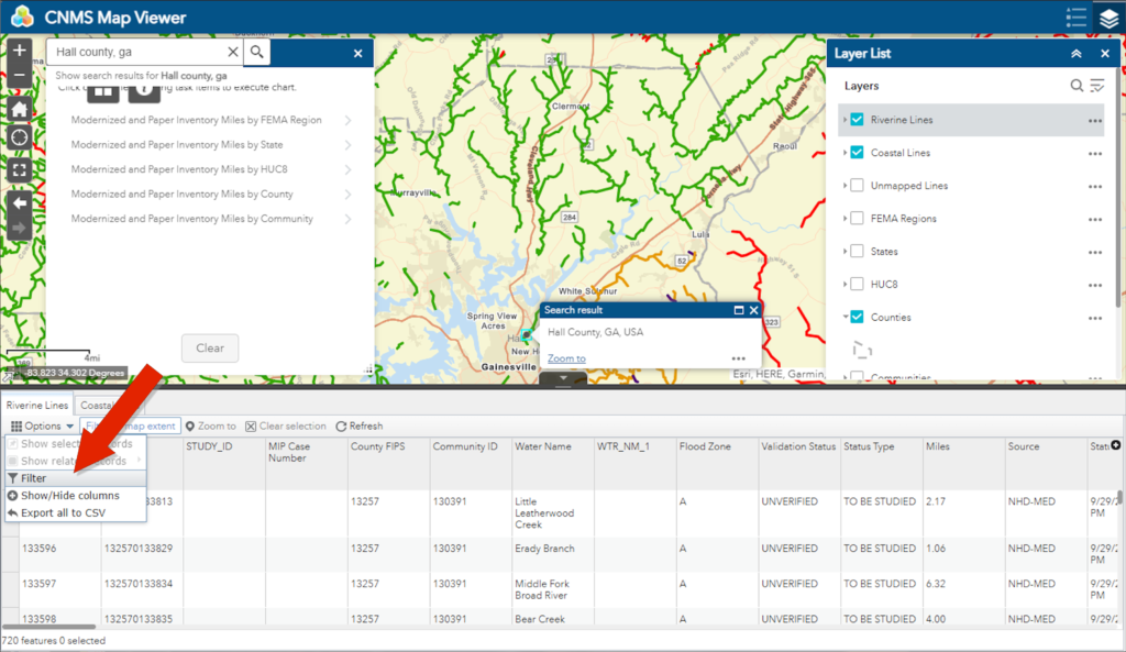
When we click the Options button, a drop down will appear. We need to click “Filter” in this drop down. A red arrow in the image below shows where this is located.
Step 7
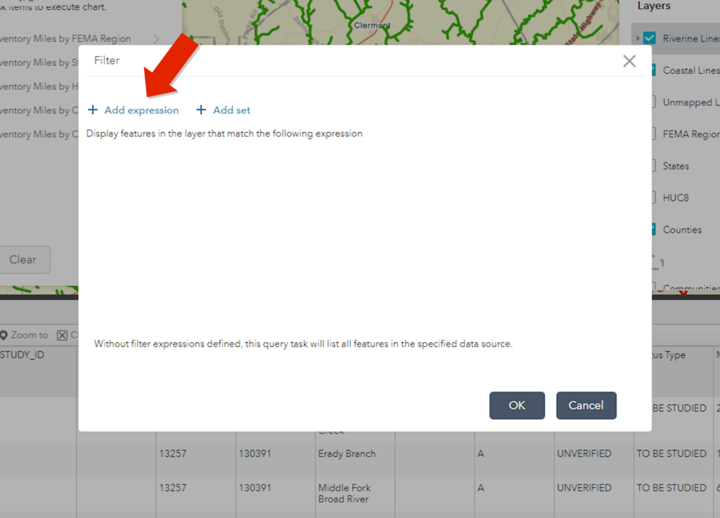
Clicking the Filter button brings up the Filter window shown below. In this window we need to click “Add expression.”
Step 8
The “Add expression” button brings up a view similar to what is shown below. We use this to build our search request. In this case, I wanted to search for wahoo which is the name of the creek. So I start by clicking the first part of the expression. A drop down of all the types of data shows up. In this list, I choose “Water Name.”
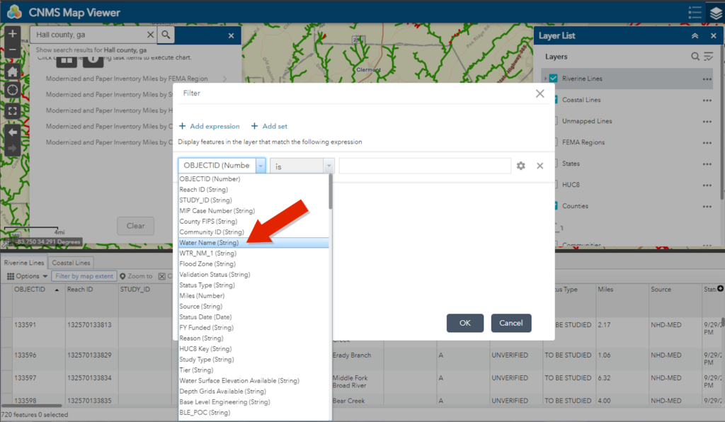
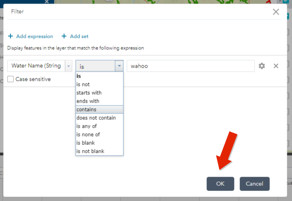
Step 9
The next part is a little tricky as it seems like we could just choose “is” and then type in the name we are searching for. But I found this does not work. The key is to choose “contains.” Although you may need to choose something else if you only know part of the name. In my case, choosing “contains” and typing “wahoo” into the next space worked. As you can see, I did not click “Case sensitive” although that is an option if necessary. Then click “OK.”
Step 10
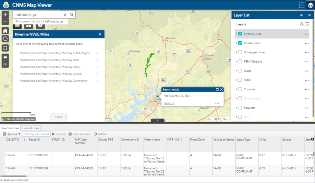
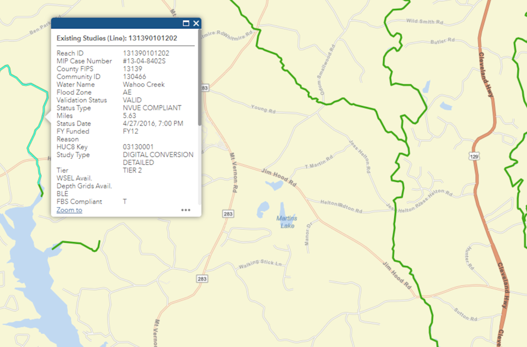
Below is the result of my search for Wahoo creek. As you can see, there is a green line displayed on the map, and there is a listing now in the Attribute Table of all segments having “Wahoo” in the water name field of the data. Keep in mind, the stream may be a color other than green as the colors are showing its status and isn’t important in our search for a name.
Step 11
I can click on this line segment to see the data and verify the line, which represents the stream or creek, is named “Wahoo.”
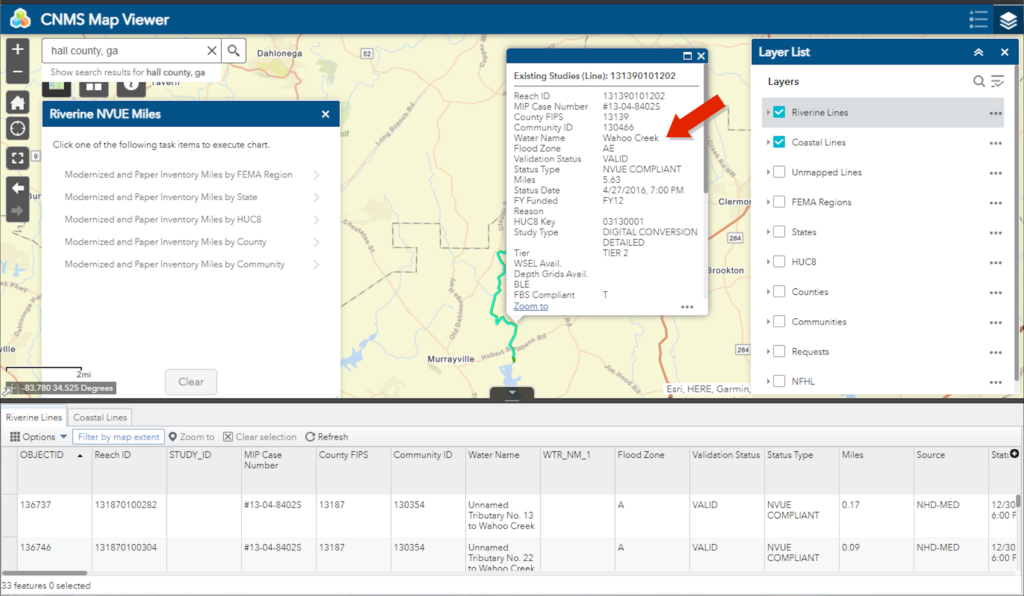
Click on the line segment to verify the name of the creek is Wahoo
Back to Joseph Patterson
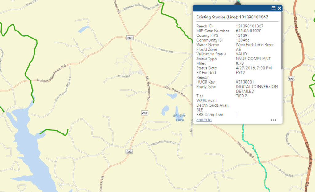
For my particular research, I noted in the transcription of the deed, the location is actually the Middle Fork of Wahoo Creek. As you can see in the images below, there is only one creek named Wahoo. I removed the filter I had created so all the stream lines would again display and checked out the creek to the east. Its name, shown in the second image below, is “West Fork Little River.”
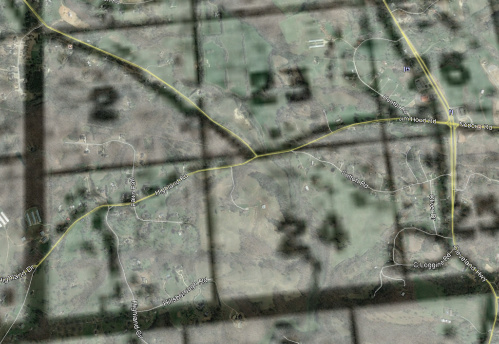
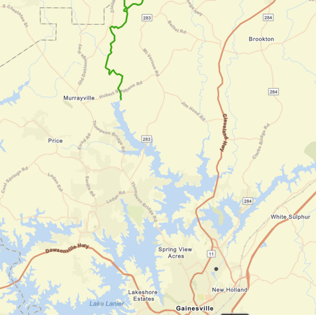
I felt confident I was still in the right area, but really wanted to find narrow down a more specific location. I wasn’t sure that I could just assume Wahoo Creek was the same as the Middle Fork of Wahoo Creek. So I looked at an overlay I had made of the districts onto Google map. Below is a zoomed in view of Lot 24 in the 12th District which was the property purchased by Patterson. While the overlay may not be placed exactly, it is close based on the roads shown on both the overlay and Google maps. From this I can tell the intersection of Jim Hood road and Sutton road are at the north boundary of Lot 24. The middle fork of Wahoo Creek should be near this location. In looking at the map above, it seems that the West Fork Little River which is just west of Cleveland Highway cuts through the intersection of Jim Hood road and Sutton road. But why is the name different from the deed?
From what I understand, the United States Geological Survey or USGS is the official keeper of stream names. In looking at an older USGS quad map of this area which is shown below, I can see both Wahoo Creek and the West Fork Little River which agrees with CNMS. But where is the Middle Fork of Wahoo Creek noted in Patterson’s deed?
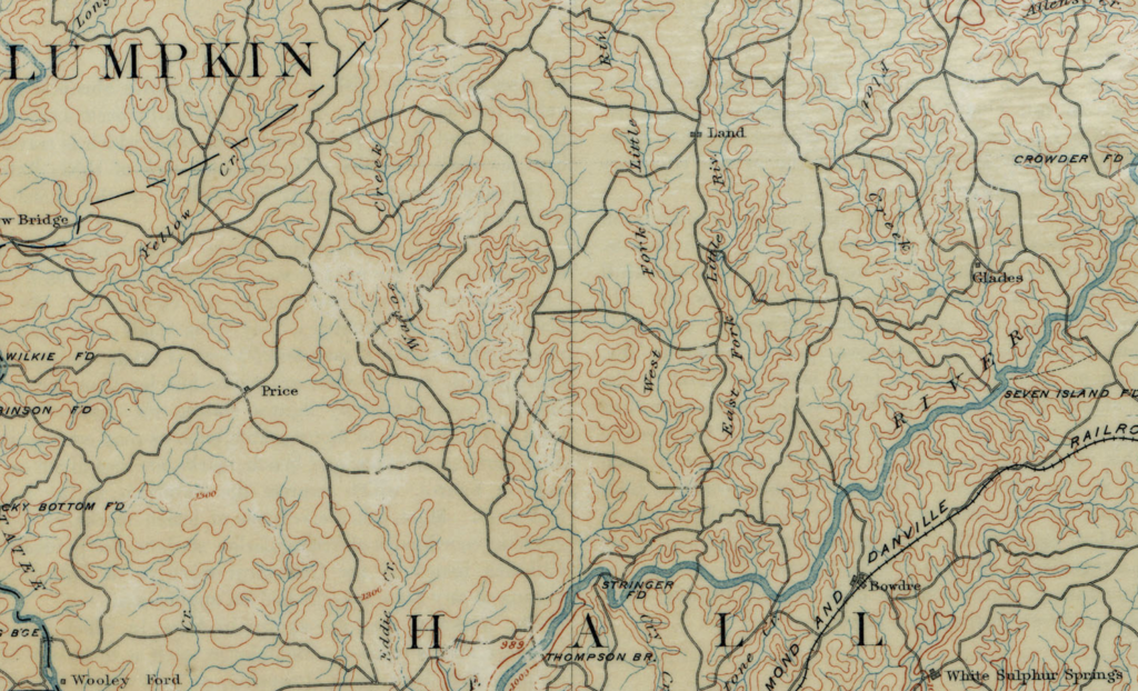
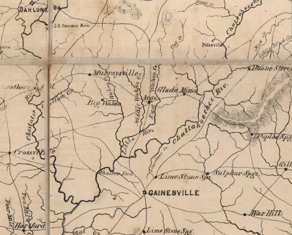
I probably could have just made the assumption the name was changed at some point between 1823 and 1891, but I wanted to take one last try at finding a map showing this area with stream names. So I went to David Rumsey’s Map Collection site and browsed for maps in Georgia in the 1800s. Finally I found one from 1864, a portion of which is shown below. Fortunately on this map, I found the Middle Fork of Wahoo Creek. I can also see there used to be an East Fork. And based on the location of the Middle Fork Wahoo Creek, it definitely appears at some point between 1864 and 1891, the name of this stream was changed to West Fork Little River. This answered my questions regarding the location of land purchased and later sold by Joseph Patterson.
But this also made me acknowledge that if I cannot find a stream in the CNMS Viewer that is mentioned in an older deed, there is a good chance it is because the name was changed at some point. I was lucky in this case that there was still a creek with a similar name in the area otherwise, I might not have found everything so easily.
I have not yet found a resource that lists names of streams that have been changed. One idea might be to contact the local historical group. For this particular area, I also noticed another change that occurred – a dam was constructed at some point on the Chattahoochee River downstream of Patterson’s land. This flooded much of the lands along the river and its tributaries including the Middle Fork Wahoo Creek/West Fork Little River. The land today must look very much different from when Joseph Patterson and his mother and brothers were living in this area.
This is wonderful! Thank you.